Besançon, France, 23 April 2013 - Digital Surf announced the official release of its new Mountains 7 software for surface imaging and metrology. New cutting-edge 3D imaging, compatible with OpenGL and Direct3D, makes it possible to visualize every detail of micrometric and nanometric surfaces in near-perfect lighting conditions. New solutions for scanning electron microscopes and Raman and FT-IR spectrometers - combined with enhanced existing solutions for 3D optical microscopes, scanning probe microscopes and profilometers - mean that Mountains 7 is the most complete surface analysis solution in its class. Furthermore, Mountains 7’s new smart user environment makes metrology report creation faster and sleeker than ever.
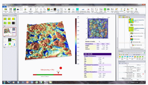
Mountains 7 comes with a completely redesigned smart user environment that makes it even quicker and easier to create a surface metrology report. Object-oriented ribbons - containing all functions relevant to the object under study - are presented automatically. All functions are accessed in a logical order thanks to the organization of all imaging, analysis and editing functions in top-down groups. Expanded graphical tooltips make all functions immediately understandable. Every analysis step is instantly recognizable thanks to the integration of clearly labeled type icons and surface data previews in the hierarchical analysis workflow. For fine-tuning on the fly, every operator is represented independently in the workflow.
To speed up analysis report creation, the visual and analytical studies that make up the body of a report have been streamlined in Mountains 7. All metrological results are grouped in a single results manager panel where tolerances can be specified, pass/fail status is displayed automatically, and results can be exported in Excel-compatible format. Layers in multi-layer surface data files - from multi-channel 3D optical microscopes and from scanning probe microscopes – are easily identified and selected with miniature icons that provide a preview of each layer. New functions include mapping of local surface properties and the automatic removal of outliers present on surfaces measured by 3D optical microscopes.
To enable easy publication, Mountains 7 is compatible with everyday Office tools. Documents are exported in PDF (no third party software required) or in Word-compatible RTF. Individual images and entire document pages can be exported in bitmap format in onscreen resolution (96 dpi) for presentations and in print-quality resolution (300, 600 or 1200 dpi) for posters.
Mountains 7 includes two major additions to the Mountains software product line. MountainsMap SEM is a new 3D imaging and metrology product for SEM’s and includes reconstruction of 3D surfaces (x, y and z in length units) from stereo pairs, anaglyphs and quads. MountainsMap Hyperspectral is a new product for Raman and FT-IR spectrometers that makes it possible to manipulate spectra and hypercubes interactively, filter them, generate compositional density maps and visualize “flattened” hypercubes in 3D. Key MountainsMap SEM and MountainsMap Hyperspectral functions are also available, respectively, in the new SEM and Spectrometry optional modules for some MountainsMap products.
Correlative studies of surface morphology and surface composition are facilitated by enhanced colocalization of images and surface data from one or more sources. For example it is possible to colocalize SEM secondary electron and back-scattered electron images and to colocalize microscope images and spectrometer density maps with 3D surface topography obtained by 3D optical microscopes, scanning probe microscopes and 3D profilometers.
“Visualizing and correlating surface data, analyzing this data and generating metrology reports are the fundamental domains that are important to our instrument manufacturer partners and end users,” stated François Blateyron, COO of Digital Surf. “Mountains 7 sets new standards in each of these domains with cutting-edge surface imaging, enhanced colocalization functionality, the broadest set of surface analysis solutions available on the market, and a new smart user environment that makes it quicker and easier than ever to create detailed and accurate metrology reports.”
Mountains 7 will be shown at the following trade shows in 2013: Control (Stuttgart, May), Nano Micro Biz (Tokyo, July), MRS Fall Exhibit (Boston, December). It runs under Windows 8 (with touch-screen compatibility), Windows 7 and Windows Vista (64 bit and 32 bit).
Digital Surf, founded in 1989, specializes in providing surface imaging and metrology software for all types of surface metrology instrument including 2D and 3D profilometers, optical microscopes, scanning probe microscopes, scanning electron microscopes and hyperspectral instruments. Imaging and analysis software based on Digital Surf’s Mountains Technology® is integrated by leading instrument manufacturers and is used in thousands of laboratories and industrial facilities working in numerous sectors including aerospace, automotive, cosmetics, energy, MEMS, materials research, medical, metallurgy, nanostructures, optics, paper, PCB, plastics, polymers, printing, semiconductor, etc.
For more information: